Showing posts with label weather alert. Show all posts

Wednesday, July 6, 2011

Strong Afternoon Thunderstorms

A persistent, juicy south-southwest low level wind  is setting up the State for an afternoon of widespread thunderstorms. As with the past few afternoon events a few isolated cells will be strong to severe with one inch hail, 40-60mph wind gusts and downright scary frequent lightning. Heavy, slow moving cells are ripe to drop 1-2 inches of a mysterious fluid called rain.  Expect better more inclusive coverage of storm cells across the State then the past few afternoons. Best chance for heaviest rain should be in a swath from Allendale/Hampton County to Marlboro/Dillon County. Storm cells begin to pop inland of the Coast after 12 noon and migrate inland. Thunderstorm cells pop Upstate-Midlands-Pee Dee after 2 PM. Heaviest rain and severe threat will be in the daytime heating sweet-spot of 4-7 PM

The high priests of high vorticity at the Storm Prediction Center in sunny Norman Oklahoma have placed the Upstate, Midlands and Pee Dee under a slight risk for severe thunderstorms; no tornadoes.

Tropics? Snooza-poolza.

Wednesday, April 27, 2011

Severe Thunderstorms

Good Morning,

Er, Toto, we might as well be in Kansas… . A very strong low pressure complex to the west heads east leaving a very violent history across Texas, Arkansas, Louisiana. Mississippi and Kentucky. More severe thunderstorms and tornadoes today for Northern Alabama, Georgia and Tennessee. Timing and dynamics, however, are in our favor…. again. The Storm Prediction Center in tornado-wise Oklahoma has a large HIGH-MODERATE probability bulls-eye to the west of us and only a slight chance for severe for the State today valid until tomorrow morning. Best ingredients for widespread severe weather outbreaks translate northeast into NC and VA.

Expect afternoon non-frontal airmass thunderstorms to develop this afternoon in the warm soupy air in place (think bucket of gasoline and toaster…). Isolated cells will be severe with 50-70 mph wind gusts, large hail, heavy rain and frequent lightning. Charming. This activity de-energizes near sunset.

The cold front to the west approaches the Upstate tonight with pre-frontal thunderstorms around midnight. The front enters the Upstate in the dark  near 2-3 AM, Midlands 05-08 AM with strong shear but diminishing  convective available potential energy. Isolated embedded strong to severe thunderstorm with damaging wind gusts to 70 mph, hail and an isolated tornado are fair game, although not with the swarm of tornadoes seen to the west. Models are showing the front slowing as it closes the coast late Thursday, re-strengthening to severe storms over the beaches on max afternoon heating.

33 shopping days until hurricane season.

Today’s forecast cartoon:


The Storm Prediction Center’s Severe Thunderstorm and Tornado Outlook for Today:


Thursday, February 3, 2011

Upstate Almost Winter Weather

Dear Winter,
This is an email I received today from WEATHERALERT.  As I said in my previous note to you, YOU SUCK!

Thanks and have a Great Day,
Keala M Jacobs

"Attempting to find short-term fixes that address the symptoms of the crisis only ensures the organization will wind up back in the same predicament."  ~~Alan Murray

From: Mark Malsick On Behalf Of WEATHERALERT
Sent: Thursday, February 03, 2011 8:13 AM
To: WEATHERALERT
Subject: Upstate Almost Winter Weather

Good Morning,

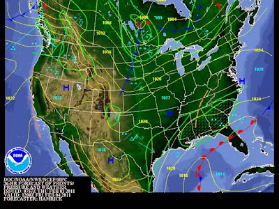
A developing surface low pressure in the central GoMex will turn on the faucet for a lengthy rainfall event starting… er, now. For most of the State this means rain, at times heavy (two-by-two rain…), tonight and all day Friday. Rain clears out before lunch Saturday.  The Upstate Quixotic wrinkle in this forecast is that from the northern Midlands and Upstate, expect periods of sleet and freezing rain Friday morning and again Friday night. Morning low temperatures will be 32 degrees along the I-85 corridor. Change over to plain rain Friday will be quick after 8 AM. Do not see any significant accumulation. Sledding: Poor.

Friday morning’s forecast cartoon courtesy NOAA/HPC:


Mark Malsick
Severe Weather Liaison
South Carolina Department of Natural Resources
State Climate Office
1000 Assembly Street Columbia, SC 29202


Related Posts with 

Thumbnails